
Arctic charting
Most requested
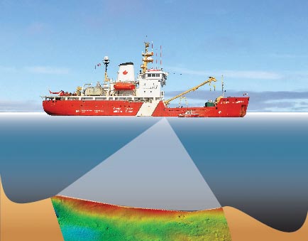
How are seabed surveys conducted?
Survey quality is determined by the accuracy of the equipment used. In general, the more recent the survey, the more accurate the data.
Areas are considered adequately surveyed where the international hydrographic standards for surveying have been met. This includes continuous bottom profiles and modern radio- or satellite-positioning systems used to survey vessel positions.
The latest surveys frequently consist of full bottom coverage using multi-beam sonar, sweep multi-transducer sweep systems and airborne laser bathymetry systems resulting in near 100% bottom ensonification which is considered surveyed to modern standards.
How much of the Canadian Arctic is charted? (updated in March 2023)
All of the Canadian Arctic is charted however many of the Arctic charts contain minimal or insufficient information to support safe and efficient navigation. Approximately 44.7% of the key navigational routes have been adequately surveyed; this includes the Primary and Secondary Northern Low-Impact Shipping Corridors.
Marine Corridor
A Low Impact Shipping Corridor is an area where there exists a measurable amount of diverse marine transportation in support of navigation activities and economic development such as community resupply, mining, oil & gas, tourism and passage.
Chronology of the modern Franklin expeditions

The Canadian Arctic stretches across northern Canada, from the Beaufort Sea east to Baffin Bay and southwards to 60° north latitude.
Canada's Arctic covers more than 4.4 million square kilometres and contains more than 36,000 islands! About 47 per cent is underwater with intricate coastlines characterised by inlets, channels, fjords and bays.
Nautical charts are the roadmaps for Canada's navigable waterways that provide mariners with the information necessary to establish sailing routes & facilitate safe passage. While approximately 15.8% of Canadian Arctic waters have been adequately surveyed, 44.7% of the key navigational routes are adequately surveyed; this includes the Primary and Secondary Northern Low-Impact Shipping Corridors.
Who is responsible for nautical charting in Canada?

The Canadian Hydrographic Service with its experts in hydrographic surveying and marine cartography, has a mandate to produce and deliver navigational charts, publications and services for Canada's vast navigable waters.
As per the Navigation Safety Regulations, 2020 of the Canada Shipping Act, 2001 and the Arctic Waters Pollution Prevention Act, ships transiting Canadian waters are required to carry and use nautical charts and related publications issued officially by, or on the authority of, the Canadian Hydrographic Service. The International Convention for the Safety of Life at Sea (SOLAS), to which Canada is a signatory, also requires coastal states to provide adequate navigational charts for its waters as a fundamental component of safety of navigation.
With whom does CHS collaborate to survey the Arctic seabed?
Partnering with the Canadian Coast Guard, the Royal Canadian Navy, Natural Resources Canada, Parks Canada, ArcticNet and others allows the Canadian Hydrographic Service to expand its ability to collect more hydrographic data across a vast and challenging environment, while also supporting Canadian sovereignty, archaeology and aquatic science.
-
One example of the Canadian Hydrographic Service's focus on collaboration to achieve common objectives includes its role in preparing Canada's submission to the Commission on the Limits of the Continental Shelf, under the United Nations Convention on the Law of the Sea. In recent years, the Canadian Hydrographic Service has worked closely with Natural Resources Canada, Global Affairs Canada (formerly the department of Foreign Affairs and International Trade), the Canadian Coast Guard and the U.S. Coast Guard to map Canada's continental shelf beyond the 200 mile limit. During that program, the Canadian Hydrographic Service successfully tested autonomous underwater vehicles as a platform for modern sonars. Other technological developments include the use of multi-beam sounders and airborne laser systems to collect water depths in near-shore areas.
-
The Canadian Hydrographic Service has also been a key player in a broader multi-party collaborative effort led by Parks Canada since 2008 in their search for Sir John Franklin's lost expedition ships HMS Erebus and HMS Terror. CHS was an essential player in the 2014 breakthrough discovery of HMS Erebus. Throughout every expedition, the Canadian Hydrographic Service has maximized the various opportunities aboard the CCGS Sir Wilfrid Laurier to survey areas of navigational priority and expand arctic marine corridors including and adjacent to the Franklin ship search areas. In 2014, CHS conducted hydrographic surveys of the area and led the bathymetric data collection and deployment of bathymetric assets on both CCGS Laurier and HMCS Kingston. HMCS Kingston's involvement with the expedition marked a new collaboration between CHS and the Royal Canadian Navy. In addition to hydrographic surveys, CHS' multibeam sonars were used to produce a three dimensional image of a sunken vessel of which the image was ultimately key to confirming the identity of HMS Erebus.
What is multibeam and how does it work?
The primary tool for the acquisition of water depths is the Multibeam Echo-sounding System, also simply known as multibeam.
Multibeam sonars transmit hundreds of beams of sound through the water, relaying the information to the computer to allow hydrographers to "see" the shape of the seafloor.
Do tides also affect Arctic surveys?

Tidal information is also key to accurate charting. Tidal data can be collected both at the surface using water observations and underwater using tide gauges that can be lowered to the seabed and released to the surface at a later date.
How does CHS determine which Arctic area is charted first?
Maritime transportation is the primary means of transport for supplies to northern communities accounting for nearly 95% of Arctic goods.
Canada's north has been experiencing slow but steady growth in maritime traffic over recent years, both local traffic and "through traffic". That trend is expected to continue with expanding ice-free seasons and increasing economic growth in the region. Additionally, tourist traffic is on the rise for both cruise ships and pleasure craft. Given the vast expanse of the Arctic, assistance can be hours away and therefore prevention is critical.
Priority is determined by assessing the following considerations in parallel; 1) where the platforms that are suitable to conduct Arctic hydrography are located during the Arctic's navigation season 2) the result of consultations with clients, and 3) alignment with where hydrography is required on the Low Impact Shipping Corridors.
- Date modified: